Friday, November 26, 2010

The Three Sisters, Australia

img-Y23075010-0001

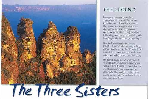
My mom bought me this postcard during her previous trip to Australia.

The Three Sisters is a rock formation in the Blue Mountains of New South Wales, Australia. They are close to the town of Katoomba and are one of the Blue Mountains' best known sites, towering above the Jamison Valley. Their names are Meehni (922 m), Wimlah (918 m), and Gunnedoo (906 m).

The Sisters were formed by erosion. The soft sandstone of the Blue Mountains is easily eroded over time by wind, rain and rivers, and the cliffs surrounding the Jamison Valley are being slowly broken up. Formations like the Three Sisters are created when water seeps into small cracks in the rock, gradually enlarging them over time to form large indentations. Eventually, the Sisters will be eroded away completely.(wikipedia)

Wednesday, November 24, 2010

Koh Kai, Koh Poda & Ao Maya

img-Y23075011-0003
Koh Kai Mu Koh Poda Krabi
Koh Kai or Koh Dam Kwan: Koh Kai or Koh Dam Kwan: Having the long beach connecting with Koh Thab and Koh Mo. During low tide, the sand bar will appear linking the three islands together looking like the sea is divided. This special scene is so-called one of the unseen destinations in Thailand.


img-Y23075010-0002
Koh Poda: The largest island of very long beach stretching to the very clear water known as the paradise for sunbathers. There are some activities provided like kayaking but only swimming is worthwhile.


img-Y23075011-0003 - Copy
Ao Maya Phi Phi Islands
Maya Bay has become the main tourist attraction of Phi Phi since The Beach was filmed here in 1999. It was always very popular before the film but now people around the world who haven't even heard of Phi Phi have certainly heard of Maya Bay.

Monday, November 22, 2010

Aloha

img-Y22075732-0001

Thank you to Christine to send me another postcard from her recent vacation.

Tuesday, November 16, 2010

East Coast, Sansiantai

img-Y15134114-0001 - Copy

Sansiantai (Chinese 三仙台 or Terrace of the Three Immortals ) is an area containing a beach and several islands located on the coast of Taitung County, Taiwan. Sansientai is a 3 hectares wide coral island. This island is covered with gigantic rocks and offers several scenic spots such as fossils, valley, wells, cave, pond, cliff and fishing platform.

Legends have it that once upon a time, three famous immortals rested on this island ; this is why it is named the Three Fairy Island.

img-Y15134115-0002

Monday, November 15, 2010

The Great Buddha , Daibutsu (Vairocana)

img-Y15134114-0001


The name Vairocana in Sanskrit means Universal Light, signifying that the infinite mercy of the Buddha is extended equally to all beings without discrimination. The position of the left hand expresses Vairocana's desire to put an end to all suffering. The right hand extends his welcome to those in the world who suffert. This image is 16 meters tall. The image and its pedastal were cast in the Nara Period (8th cent.), but they have been repaired many times over the ages. Very little remains of the original work. The hands, for example, were made in the 16th century, and the head and the wooden screen behind it are from the 17th century.

Thursday, November 11, 2010

Caernarfon Castle, Gwynedd, Wales

img-Y10075229-0002

On the site of an early motte, this tremendous construction was built after 1283 and took over 40 years to build (that is its basic construction) being chiefly designed by James of St.George. Master of the King's Works in wales, the king being Edward I.


img-Y10074733-0002

Tuesday, November 9, 2010

Amur Bridge in Khabarovsk, Russia

img-X29140944-0002 - Copy

The Amur River or Heilong river is the worlds sixth longest river in the world,the border betwen the Russian Far East and Northeastern China

The Khabarovsk Bridge (1916) was a railway bridge that carried the Trans-Siberian Railway across the Amur River near the city of Khabarovsk, Russia. Measuring some 2,590 meters (about 8,500 feet) in length, the structure remained the longest bridge in Imperial Russia, Soviet Union and Asia for decades.


img-X29140944-0001 - Copy

Monday, November 1, 2010

Capitol Reef National Park

img-X20075500-0001

Christene send me another card in case I didn't receive the big one. Such generous her, I received both.

Capitol Reef National Park comprises 378 square miles of colorful canyons, ridges, buttes, and monoliths. About 75 miles of the long up-thrust called the Waterpocket Fold, extending like a rugged spine from Thousand Lake Plateau southward to Lake Powell, is preserved within the park boundary. Capitol Reef is the name of an especially rugged and spectacular part of the Waterpocket Fold near the Fremont River.

The Temple of the Sun & Moon stands illuminated, as the day fades away.

img-X20075516-0001